Seven Rila Lakes: How to Hike Bulgaria's Most Famous Trail on Your Own
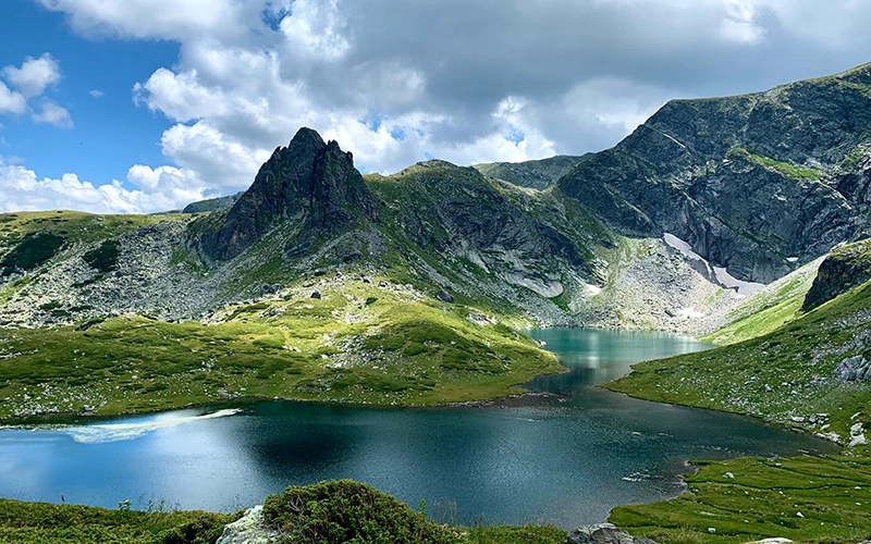
The Seven Rila Lakes are Bulgaria's most visited natural site, and they are entirely possible to reach without a guide. The lakes sit between roughly 2,095 m and 2,535 m in the northwestern Rila Mountains, about 90 km south of Sofia. All seven are glacial in origin, carved by ice and fed by snowmelt. The full loop takes most people four to six hours. What stops travellers is rarely fitness - it is bad information about the chairlift, the weather and the timing.
This guide fixes that. It is written for people who want to drive or bus themselves there, walk at their own pace, and come home the same day.
What the Seven Rila Lakes Actually Are
Each lake is named for its shape or character. Knowing them in order makes the trail self-explanatory, because you climb past them from lowest to highest.
- The Lower Lake (Dolnoto) - 2,095 m, the lowest. Its outflow forms the Dzherman river.
- The Fish Lake (Ribnoto) - 2,184 m, the shallowest at around 2.5 m deep.
- The Trefoil (Trilistnika) - 2,216 m, with an irregular three-lobed shoreline.
- The Twin (Bliznaka) - 2,243 m, the largest by surface area, pinched into two halves.
- The Kidney (Babreka) - 2,282 m, with the steepest banks of the group.
- The Eye (Okoto) - 2,440 m, almost perfectly oval and the deepest glacial lake in Bulgaria at about 37 m.
- The Tear (Salzata) - 2,535 m, the highest, named for water so clear you can see the bottom.
The classic viewpoint is Peak Haramiya, above the Tear. From there all seven are visible at once. That view is the reason most people come.
Getting to the Seven Rila Lakes From Sofia
By car - the practical choice
Drive south from Sofia on the A3 Struma motorway, exit toward Dupnitsa, continue through Sapareva Banya, then climb to Panichishte. Total distance is about 90 km and takes 1 hour 30 to 1 hour 45 minutes. The final section above Sapareva Banya is paved but steep and full of switchbacks. Drive it in daylight.
Park at the Pionerska chairlift base station. There is a paid car park. On summer weekends it fills before 9 am.
By public transport
There is no direct bus to the lift. The realistic chain is: bus or train from Sofia to Dupnitsa, local bus to Sapareva Banya, then a taxi for the last 10 km to Panichishte. Budget two and a half to three hours each way and agree the taxi return in advance - phone signal in Panichishte is patchy.
Seasonal shuttle services from Sofia also run in high summer. They are worth checking if you have no car, because the taxi leg is the weak link in the whole plan.
The Chairlift: The Detail Most People Get Wrong
The Rila Lakes chairlift runs from Pionerska (around 1,570 m) to a point near the Rila Lakes Hut (2,150 m). The ride takes 20 to 30 minutes and saves a 515 m forest climb of roughly 1.5 to 2 hours each way.
Four things to know before you rely on it:
- It closes on the last Monday of every month for technical maintenance. This catches out more visitors than anything else.
- Mondays start late. Outside peak summer the first ride is often 12:30 rather than 9:00, which cuts your hiking window in half.
- There are two annual maintenance shutdowns, typically around two weeks in October and again in April or May. Exact dates are announced late.
- Card payment is unreliable. Mountain internet coverage drops out and the terminal stops working. Bring euro cash. Bulgaria adopted the euro on 1 January 2026 and it has been the sole legal tender since 1 February 2026.
Strong wind and thunderstorms suspend the lift without warning. Check the operator's page the morning you travel, not the week before.
You can also skip the lift entirely and walk up from the base. It is a fair forest path, but it adds three to four hours round trip to an already long day. Only do this if the lift is shut and you are genuinely fit.
The Walking Route, Step by Step
The standard loop from the upper lift station is 10 to 12 km with roughly 500-600 m of ascent. Here is the sequence that works best:
- Upper lift station to the Rila Lakes Hut - 10 minutes. Last toilets, last shop, last reliable water refill.
- Hut to the Lower Lake and Fish Lake - 30 minutes on a wide, gentle path.
- Climb past the Trefoil, Twin and Kidney - about an hour. The gradient increases here.
- Ascend to the Eye - 40 minutes on a rockier section with some loose stone.
- Final push to the Tear and Peak Haramiya - 30 to 45 minutes. This is the steepest part and the only one that feels like real mountain terrain.
- Descend the eastern side back to the hut - 1.5 hours on an easier gradient.
Marking is good. Trails are colour-blazed and there are wooden signposts at junctions. A downloaded offline map is still sensible, because fog rolls in fast above 2,400 m.
A shorter option
If you have children or limited time, walk only to the Kidney and back. That is roughly two hours total and still gives you four of the seven lakes plus the best reflections.
Pros and Cons of Going Self-Guided
What you gain
- Timing control. You can be at Peak Haramiya at 9 am before the crowds and the cloud. Organised groups usually arrive between 11 and 13.
- Lower cost. Fuel, parking, park fee and lift ticket typically total under €30 per person for two people sharing a car.
- Flexibility. If the summit is in cloud you can wait an hour. A tour bus cannot.
What you give up
- Weather judgement. Afternoon thunderstorms are common from June to August and the upper ridge is exposed. A guide reads this for you.
- Transport certainty. Without a car the last 10 km is a genuine logistical problem.
- Context. The geology and the park's protected status are not explained on the trail.
Expert Tips That Change the Day
- Start with the first lift. The queue for the last descent regularly runs past an hour on summer weekends. Going up early means coming down early.
- Avoid the last Monday of the month. Non-negotiable, and it is the single most common wasted trip.
- Pack layers, not bulk. The ridge sits 10-12°C colder than Sofia and wind chill at 2,500 m is significant even in July.
- Carry 1.5 to 2 litres of water. There is no safe drinking source above the hut. Lake water is not treated.
- Wear boots with ankle support. The upper sections are loose rock and the descent is where most injuries happen.
- Best window is mid-June to early October. Snow patches linger into June and return in late October. July and August are warmest but busiest; September gives clear air and thin crowds.
- Pay the Rila National Park entry fee at the base. It is small and it funds trail maintenance.
- Take your rubbish down. Bin capacity at altitude is limited and the area is a protected reserve.
Where to Stay if You Want Two Days
The Rila Lakes Hut offers basic dormitory beds at 2,150 m. Book ahead in summer. Staying overnight lets you reach the Tear at sunrise, when the lakes are still and empty - the best conditions of the entire day, and something no day-tripper sees.
Panichishte and Sapareva Banya both have guesthouses and hotels lower down. Sapareva Banya also has Europe's hottest geyser spring, at 103°C, and mineral baths that are worth an hour after a long descent.
Final Thoughts
Hiking the Seven Rila Lakes independently is well within reach for anyone with normal fitness and a bit of preparation. Get the chairlift timing right, start early, dress for the ridge rather than the car park, and give yourself a full day rather than a squeezed afternoon. Do that, and the Seven Rila Lakes will deliver the single best mountain day Bulgaria has to offer.